Showing 40 items matching landscape technology
-
 University of Melbourne, Burnley Campus Archives
Certificate, VCAH Burnley Certificate for Landscape Technology, c. 1983-1996
... VCAH Burnley Certificate for Landscape Technology...landscape technology... for Landscape Technology Sample certificate for an award ...Sample certificate for an award of an accredited Technical and Further Education Certificate certificates, tafe, technical and further education, landscape technology, vcah -
University of Melbourne, Burnley Campus Archives
Document, Submission for re-accreditation M.L. Special Course in Landscape Technology 1984 (Course code 23FFN)
... Landscape Technology 1984 (Course code 23FFN)...Landscape Technology...-accreditation M.L. Special Course in Landscape Technology 1984 (Course ...burnley, landscape technology -
 The Beechworth Burke Museum
Photograph, Unknown
The A1 Gold Mine is located north of Woods Point, near Jamieson, in the Upper Goulburn region of Victoria. Gold was discovered at the A1 site in 1861 and mining operations began in 1864. The A1 Mine Settlement refers to a small township known variously as Castle Reef, Castle Point, and Raspberry Creek, which developed in the 1860s around mining industry centred on a crushing machine that worked the three gold reefs in the area. Historically, the name "A1"referred to the high quality of gold found in the quartz reefs at depths of at least two thousand feet. Along with the Morning Star mine at Woods Point, the A1 gold mine produced almost sixty percent of Victoria's gold output in the 1950s to 1970s and continued operating until 1992 when it went into administration. Operations at the site were revived in 2016 and the A1 Mine is now considered one of Victoria's premier gold mines. The A1 mine is part of the extensive and prospective Lachlan Fold Belt, a north-west trending belt of tightly folded Early Devonian sedimentary rocks extending from New South Wales to Victoria. Mineralisation is hosted within or immediately adjacent to diorite dykes. Contemporary development of the 'Queens Lode' at the A1 mine signals a move from high-grade, narrow vein airleg mining into larger scale, mechanical mining designed to increase ore production volume. This original, undated photograph of the A1 Mine appears to depict an area or phase of disuse or abandonment. The aged and humble appearance of the cottage suggests association with the historical A1 Mine Settlement, therefore the image may have been taken prior to the 1950s-1970s revival period in which the A1 mine is known to have produced high gold yields. The photograph contributes to our understanding of the A1 Gold Mine's impact on the landscape and the social, environmental impacts of mining on communities and may be compared with others in the Burke Museum's extensive collection of mining photographs to deepen our understanding of mining in the Jamieson area.Black and white rectangular photograph printed on photographic paperReverse: 5577 / A1 Mine / Near Jamieson / Vic. /burke museum, beechworth museum, beechworth, gold fields, gold rush, victorian gold rush, mining tunnels, gold ming history, colonial australia, australian gold rushes, mining technology, beechworth historic district, indigo gold trail, indigo shire, upper goulburn shire, jamieson, woods point-walhalla goldfield, a1 gold mine, victorian high country, modern mining methods, orogenic gold province, gold mineralisation, devonian, dykes -
 The Beechworth Burke Museum
Photograph - Photograph - Reproduction, ca. 1900
This image shows the approach to Beechworth from the south-west via the Newtown Bridge. Numerous early buildings line the road as it bifurcates to become Ford and High Streets on the ridge above Spring Creek and Newtown Falls. The sloping, rocky terrain and water course along the gorge show evidence of the intense mining activity that occurred at the site. The Ovens Gold Rush at Beechworth started when gold was found at Spring Creek in February 1852, prompting an influx of miners from around the world. The population grew over 20,000 by 1857. While the earliest mining at Beechworth was similar to that in other Victorian goldfields like Ballarat and Bendigo, Beechworth is notable for its use of hydraulic sluicing as a major method of removing wash-dirt. Hydraulic sluicing employs high pressure jets of water to blast away large areas of earth and wash it down to be run through a sluice box. Gold gets caught in the sluice and the remaining slurry is washed away. This method of mining is extremely effective but causes significant environmental impacts and damage to waterways. Large water quantities were required for large-scale sluicing, and the long water races and deep tailraces that were constructed in the Beechworth area in the nineteenth century are nonetheless considered feats of engineering. The site in the photograph is associated with the Rocky Mountain Mining Company who constructed an eight hundred meter tunnel under the township between 1876-1880 to reduce water levels at Spring Creek, which had been subject to diversions since the earliest days of alluvial mining. Over four million ounces of gold (115 tones) were found at Beechworth between 1852 and 1868, and the wealth from the gold rushes built Beechworth and the nationally significant buildings that remain standing today.This image shows the early development of the Beechworth township above Spring Creek, where gold was discovered in 1852. Evidence of hydraulic sluicing, a uniquely predominant method at Beechworth, and water-works engineering are present in the landscape. By the 1870s, alluvial gold deposits were depleted and increasingly complex engineering was required so deeper shafts could reach bedrock. This image is significant for understanding changes to the landscape and the evolution of mining methods and engineering practices related to the extensive construction, manipulation and management of water networks. The shift from smaller scale alluvial mining to larger company dominance in the mining industry has implications for understanding wider social, economic, political and industrial changes in the region of Beechworth and within the context of the Victorian Gold Rush more broadly. A black and white rectangular reproduction photograph printed on photographic paper. burke museum, beechworth museum, beechworth, gold fields, gold rush, victorian gold rush, hydraulic sluicing, rocky mountain mining company, spring creek, netwown falls, mining tunnels, water races, tailraces, colonial australia, australian gold rushes, mining technology, beechworth historic district, indigo gold trail, migration, indigo shire, gold mining, gold mining history -
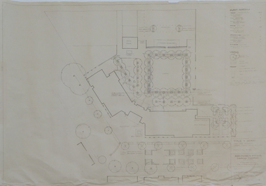 Federation University Historical Collection
Plan - Plans, Ballarat School of Mines Brewery Building Plans, 1995
The Ballarat School of Mines Brewery Building is now a part of the Ballarat Technology Park.Site plan and landscape plan for Stage 3 works for the Ballarat School of Mines Brewery Building. .1) Site plan by Philip Cox Sanderson & Partners, Melbourne .2) Landscape plan by John Patrick Pty Ltd, Landscape consultants, Kew, Victoriaballarat school of mines, brewery building, ballarat technology park, john patrick, philip cox sanderson, landscaping, archtectural plans -
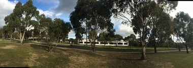 Federation University Historical Collection
Photograph - Colour Photograph, Clare Gervasoni, Ballarat Technology Park, 2015, 13/08/2015
Colour photographs of buildings and landscape associated with the Federation University Technology Park.ballarat technology park, federation university technology park, state revenue office, ibm, canadian wetlands, berry street, ibm-issc-southern data centre plaque, roger hallam, geoffrey blainey, david james, global innovation centre, cic, greenhill -
 Flagstaff Hill Maritime Museum and Village
Functional object - Cow Bell, Circa 1878
The artefact is a brass cow bell recovered from the 1878 shipwreck of the LOCH ARD near Port Campbell. It was raised by Flagstaff Hill divers in 1973 and is in storage at the Maritime Village. A cow bell is a bell worn around the neck of free-roaming livestock so herders can keep track of an animal via the sound of the bell when the animal is grazing out of view in hilly landscapes. Although they are typically referred to as "cow bells" due to their extensive use with cattle, the bells are used on a wide variety of animals. The earliest examples of truly recognizable cow bells date back to the Iron Age. The use of iron bells in sub-Saharan African music and the Niger–Congo area is linked to the early iron-making technology spread during the Bantu migrations. The earliest archaeological evidence of bells dates back to more than 5000 years ago, from the 3rd millennium BC in Neolithic China. During this era, there is evidence of early forms of pottery cow bells, which were likely used to keep track of goats, sheep, and cattle. These pottery bells were later replaced by metal bells using brass and other materials. The LOCH ARD was constructed on the Clyde in 1873 for the prestigious Loch Line of colonial clipper ships, designed for the Australian run. She sailed from England on 1 March 1878 carrying 37 crew, 17 passengers and a diverse general cargo ranging from luxury items to bulk railway iron. On 1 June 1878, emerging from fog and hearing too late the sound of breakers against the tall limestone cliffs, the vessel struck the southern foot of Mutton Bird Island and sank in 23 metres of water. Of the fifty-four people on board only two survived, one young male crewman, Tom Pearce, and one young female passenger, Eva Carmichael. (See References or Notes below for further details.)The cow bell is believed to be part of the cargo of the Loch Ard and this shipwreck of the Loch Ard is of historical significance for Victoria. Registered on the Victorian Heritage Register ( S 417), with Flagstaff Hill having a varied collection of artefacts from the Loch Ard. Its collection is significant for being one of the largest accumulation of artefacts from this notable Victorian shipwreck. The collections object is to also give us a snapshot into history so we can interpret the story of this tragic event. The collection is also archaeologically significant as it represents aspects of Victoria's shipping history that allows us to interpret Victoria's social and historical themes of the time. The collections historically significance is that it is associated unfortunately with the worst and best-known shipwreck in Victoria's history. Brass cow bell, covered in encrustations. flagstaff hill, warrnambool, shipwreck coast, flagstaff hill maritime museum, flagstaff hill maritime village, maritime museum, great ocean road, shipwreck artefact, loch ard, mutton bird island, glenample, eva carmichael, tom pearce, flagstaff hill divers, cow bell, horse bell, bell smith, vintage bell, farmer, shepherd, drover, stock bell, brass bell -
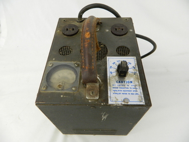 Kiewa Valley Historical Society
Transformer Lamp System, late 1950's
This transformer lamp system, which has a dial to transform 240 volts to a minimum of 32 volts was used by electrical technicians to inspect internal parts of the large generators (even in small confined spaces). The reason for the reduction of the 240 volts to the 32 volts was for the safety of the inspector. The SEC Victoria Hydro Scheme's electrical generators are powered by the hydro force of "stored" water at a higher altitude. The establishment of both the NSW and Victorian Hydro schemes was achieved from the mid 1900's to the 1960's. At this the point in time the need for additional power sources to quench both an industrial and domestic demand for electricity was purely an economic and not and environmental (carbon reduction) factor. This hydro scheme was instigated by "the Government of the day" as a bold move and was the major force of the World War II refugee and "technical" workforce inclusion of skilled and unskilled migration into the Australian environment. Although this mass "invasion" of workers with families was thought of in some circles as intrusive, the expansion of population post war years and its integration into the Australian rural sector, produced the multi- lingual multi-cultural diversity of later years.This transformer lamp is very significant to the Kiewa Valley as it was introduced as a very small part of the explosion of human resources into the valley. This influx of population transformed the region from that of a basically quiet rural region to one which evolved into both industrial and larger residential community. This evolution in the valley created a change, not only in the "physical" landscape but also the socio-economic expansion which permitted other "tourist" based industries into the valley. This is also a specific electronic item which was manufactured in Melbourne and not sourced from Europe or Asia. This demonstrates the fast evolution of Australian technology to a high standard compatible to that of the rest of the world.This heavy hand held electrical transformer (transforms 240 volts to 32 Volts) an has one leather handle on the top with three small (gauze filtered) air holes. It also has two 2 pin directional cable distribution (clipsal) in/out points 10amps / 240 volts. There is one glassed in volts/ac meter and one variable switch (180 to 150 voltage in settings of 10 volt increments.There are two vents (one on each of the smaller sides). There is also one three pin electrical lead coming out from the top.On one side is a manufacturer's plaque with "ELECTRONIC A & R EQUIPMENT MELBOURNE" and underneath "TYPE 1719, PRI V. 180 250" underneath "V.A. 1250" underneath "CYC 50" underneath "SEC V. 115" underneath "SEC A. 10 . 8". The label on topside "CAUTION SET SWITCH TO 250 v BEFORE CONNECTING TO MAINS THEN, WITH EQUIPMENT OPERATING, SET METER TO RED LINE.kiewa hydro electricity scheme, victorian state electricity commission, transformers -
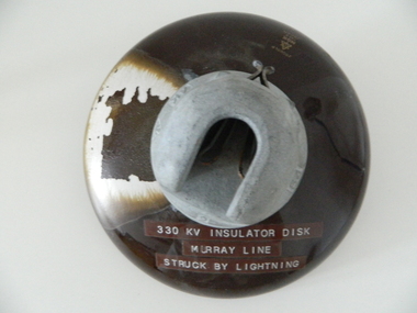 Kiewa Valley Historical Society
Insulator Disk High Voltage, 1964
This insulator disk for the high voltage carrying electrical cables was manufactured in 1964 and used by the SEC Vic (Kiewa Hydro Electricity Scheme) from that date until late 1900's. It was used to connect high voltage cables to their "towers" going from various Hydro Generators to and from power "stations". During this time period, high quality "cable" insulators were manufactured in Japan. In an earlier time they would have been sourced from Europe or England. After the 1950's the sourcing of electrical hardware was being influenced by the lower costs obtainable from Japan. Later on other Asian sources also became available.The need for a mountainous and a large area of operational requirements, such as the SEC Vic Kiewa Hydro Electricity Scheme, to distribute the electricity produced in the Victorian Alps to the major users required power transmission lines to "carry" high above the sometimes inaccessible land mass electricity generated at the power stations to the various sub stations along the valleys and ranges to flatter populated regions. The significance of this insulation "high voltage" disk to the Kiewa Valley region relates to the impact of modern technology (at that time) upon a mainly rural environment. These power lines are a stark visual "show" of the impact that the "Scheme" has on the mostly rural landscape of the Kiewa Valley and what a boost of "modern" equipment into the area has taken place. The "Hydro Scheme" had facilitated the transition of a semi rural area to an advanced rural region within a shorter time frame, than would have taken under "normal" evolutionary time. The speed of information of all "new technology" had a relatively slow assimilation rate before the SEC Kiewa Hydro Scheme came to those living in the then quieter rural communities. This high voltage (330 KV) insulation disk is made from non conductive porcelain stoneware. It is highly polished brown in colour and has a clip fastening for the high voltage cable to be attached to. This disk was hit by lightning and the burn marks are quite noticeable. The top metal connector has a "mushroom" extension jutting below the semi cone like insulation disk. Also four circular ridges or grooves (old 78 rpm disc recording style).Cable bell on top of insulation disk "4K " next to it the international symbol for electricity (triangle containing one horizontal line under one V line and one vertical flame like line.) On the opposite side "2" and to the right "64"sec vic kiewa hydro scheme, alternate energy supplies, alpine (above ground) high voltage electricity cables, volt cable, 330000 volt cable -
 The Beechworth Burke Museum
Photograph, 1920-1950
This image taken between 1920-1930 depicts open-cut hydraulic sluicing at the Three Mile Mine, located about five kilometres south of Beechworth. Alluvial, or surface, mining began on this site in the 1850s, but was soon replaced by hydraulic sluicing methods. By the start of 1880 it is estimated that nine hundred miles of water races had been cut though soil and rock in the Beechworth district. Hydraulic sluicing employs high pressure jets of water to blast away large areas of earth and wash it down to be run through a sluice box. Gold gets caught in the sluice and the remaining slurry is washed away. Large water quantities were required for hydraulic sluicing, and the long water races and deep tailraces that were constructed were considered great engineering feats. This method of mining is extremely effective, but causes significant environmental damage and impacts to waterways and agricultural operations. Miners at Beechworth built extensive networks of races and dams to secure reliable supplies of water on a scale far greater than elsewhere in Victoria. By the 1880s Beechworth's water barons continued to hold more than half of all the water right licences on issue and undertook sluicing operations on a massive scale. The manipulation of surface and ground water via race networks was well planned and recorded in detail by local mining surveyors. The maps that were created, combined with modern geo-spatial technologies, provide a vital key in understanding the great lengths to which miners went to capture and control critical water resources. Today, Three Mile mine is called Baarmutha. The Three Mile Mine was unproductive until 1865 when John Pund and three other miners secured a fifteen year license and constructed a water race from Upper Nine Mile Creek to Three Mile Creek. In the early twentieth century Pund & Co. averaged over one thousand ounces of gold per year from the mine. After Pund's death in 1915, GSG Amalgamated Co operated the site, continuing sluicing until 1950. This image of hydraulic sluicing methods shows the extent of water-works engineering in the landscape. This photograph has historic and research potential for understanding changes to the landscape, the evolution of mining methods, and the extensive construction, manipulation and management of water networks in the Beechworth district. Black and white rectangular photograph on matte paperReverse: 7597-1 / Sluice Mining / Copied from original on loan from Webb (Qld) / Donated Nov 2009 / Baarmutha Three Mile Mine c1920-1950 / Managed by the Plain Bros then Parkinsons / Current Location is: Beechworth Animal Shelter / used for Baarmuthaburke museum, beechworth museum, beechworth, gold fields, gold rush, victorian gold rush, hydraulic sluicing, spring creek, netwown falls, mining tunnels, water races, tailraces, gold ming history, colonial australia, australian gold rushes, mining technology, beechworth historic district, indigo gold trail, indigo shire, john pund, water manipulation, water engineering, three mile creek, three mile mine, water race, large-scale mining methods, historical mining construction, alluvial mining, mining environmental impacts, baarmutha, water barons -
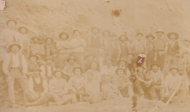 The Beechworth Burke Museum
Photograph, Walter William McLean Thwaites, c.1870
This photograph depicts a large group of men in their work clothing situated in front of a large bank of earth. They are identified as miners working in an unidentified location in Australia. This photograph was taken by photographer Walter Thwaites sometime during the period of 1865-1908, likely c.1870. It is unsure where this image was taken since Thwaites travelled a lot over his photography career and the photograph is not annotated with this information. In addition, the identities of the men in the photograph are also unknown. These men are photographed in front of a large bank of earth where they had presumably been mining for gold or other precious metals. The men, with the exception of four, are wearing wide brimmed hats to protect their faces from the sun. They are also wearing loose fitting white shirts which are often worn beneath a darker coloured vest. They wear pale coloured work pants and boots. The men are mostly clean shaven with the exception of the moustache and a couple of beards. Two of the men have pipes in their mouth. Their clothing is basic and much less dramatic than the outfits worn by the gold diggers of the 1852 gold rush. These men, by wearing similar outfits, are expressing a sense of comradery or equality between them. It is likely that they are from the same, or similar, social status. They have an air of independence and share social equality in their stance and clothing. Walter William McLean Thwaites (1840-1908) was a professional photographer born in Sydney, Australia. He learnt the craft in his father's Hobart studio, but later embarked on his own solo career and toured every existing Australian colony between 1860 to 1888. The Thwaites family were a long line of photographers and artists with Thwaites' father Walter WIlliam Thwaites Sr working as an artist and photographer in Australia after moving from England in 1834. Walter Thwaites Sr's father, also named Walter Thwaites, was a British miniature portrait artist.Images, like this one, of Australian gold rush history can reveal important information about the social and environmental impact of this period. This image depicts over 30 diggers standing in front of a bank of earth and therefore, this image has the capacity to reveal or support significant information for researchers studying the fashion and social status of diggers in Australia in approximately 1870. It can also provide information on the landscape of Australia in this period and the impact of mining for gold on both society and the Australian landscape. The Burke Museum is home to a substantial collection of Australian mining photographs which can be used to gain a deeper understanding into life on the gold fields, technology used in mining, the miners themselves and the impact of the gold digging on the environment.Sepia toned rectangular photograph printed on matte photographic paper and mounted on board.Reverse: 1997.208 / MINERS. / W. Thwaites / Photography /australia, australian photography, photography, miners, gold rush, australian landscape, diggers, walter thwaites, thwaites photography, w. thwaites photography, social history -
 The Beechworth Burke Museum
Photograph
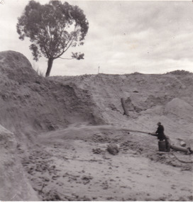
This photograph depicts a man in dark clothing, standing in front of a cut away section of earth. He is undertaking hydraulic sluicing, which involves the use of high powered hoses, in order to cut away the earth which can then be sifted for gold. There is a single tree in the background and the earth contains numerous signs of damage because of the mining. Beechworth become a mining settlement after the discovery of gold in 1852. Gold fever had already spread across Australia's colonies and the American states. Sluicing the landscape for gold, as shown in this photograph, was done by diverting water and washing away the lighter dirt, allowing the gold particles to sift down in to catchments for collection. In Beechworth, there was considerable discontent caused by attempts to restrict water use for sluicing to those with certain 'water rights'. The extensive use of hydraulic sluicing, and the washing away of top soils has continued to impact the surrounds of Beechworth in to the present day. Sluicing as a method for gold mining which was widespread across Victoria during the 1870s. The erosion of the top soil in search of gold has a continuing environmental impact on the landscape and this photograph depicts but one example of this occurring and can provide much information to a researcher interested in understanding the history of gold mining in Victoria. This image of the miner and hose is historically important because it demonstrates the methods of goldmining employed in the later years of the goldrush at Beechworth. It shows how much land is washed away by the use of this technology. The image has good interpretive capacity because it allows researchers to see a different mining technique to what is usually presented. Black and white square photograph on card.reverse: 84-50-3 / 1997 3141 / smdsluicing, goldmining, beechworth, burke museum, miners, gold miners, gold sluicing, environmental impact -
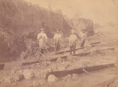
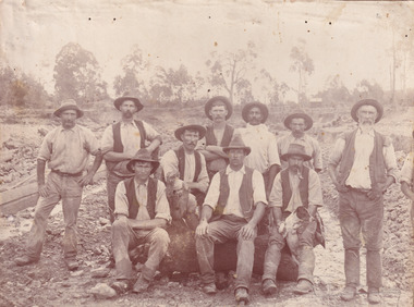 The Beechworth Burke Museum
Photograph, c. 1870
This photograph was captured at an undisclosed location and at an unidentified time but likely dates to approximately 1870. The photographer's details are not recorded and the identities of the men in the image are also not known. This image depicts a group of 10 men in typical miners fashion. Four of them are sat on a large log with one holding a small dog. Six miners stand behind those sitting. All these men are wearing a white button-up shirt and tan coloured work trousers. They wear heavy boots and seven have included a dark vest over their shirt. The man holding the dog has a pipe in his mouth. Two of these men are clean shaven with the remainder sporting a moustache and two with a beard. The ages of these men vary from late 20s to middle age. This group of men are located in a mining location with what appears to be an open cut mine in the background of the image. The ground is muddy and has elements which can help identify it as a mining location based on the condition of the landscape. The bottom of the men's trousers are muddy which provides the assurance that these men were working in this location when their photograph was captured. In the background there is one structure, possibly a dwelling, and bush which identifies the location as Australia. Open cut sluicing is a method used to extract gold and other precious metals from beneath the surface of the earth. This technique involved the use of high-powered hoses which broke down the soil enabling miners to come along and search this soil for gold. After the gold rush of the early 1850s, diggers had to enlist the assistance of heavy machinery and techniques like hydraulic sluicing in order to reach gold because the surface alluvial gold had already been discovered and removed. This heavy machinery was not used until after 1853. The search for gold is ingrained into the history of Victoria and therefore, images like this one which portray an open cut sluicing site can reveal important information for society and technology for the date when the photograph was taken. This image is of important historical significance for its ability to convey information about sluicing and the methods used to find gold in the late 1800s and early 1900s. It also shows a location where sluicing was undertook which provides insight into the impact of sluicing on the environment at a time when it was done. Images, like this one, of Australian gold rush history can reveal important information about the social and environmental impact of this period. This image depicts diggers standing in a mining location and therefore, this image has the capacity to reveal or support significant information for researchers studying the fashion and social status of diggers in Australia in approximately 1870. It can also provide information on the landscape of Australia in this period and the impact of mining for gold on both society and the Australian landscape. The Burke Museum is home to a substantial collection of Australian mining photographs which can be used to gain a deeper understanding into life on the gold fields, technology used in mining, the miners themselves and the impact of the gold digging on the environment.Sepia toned rectangular photograph printed on matte photographic paper mounted on board.Reverse: 1997.2518mining, goldfields, beechworth, 1870, australia, australian goldfields, diggers, victoria, sluicing, gold mining, miners, diggers victoria -
 The Beechworth Burke Museum
Photograph, c.1870
This photograph was taken in approximately 1870 and depicts four male miners standing in mining sluice at the Three Mile Goldfields. These men are wearing typical attire for 1870s gold miners. They wear white shirts, tan coloured pants with water proof shoes and most of the men are wearing an apron to prevent their clothing from becoming too dirty from the mud. Each man is wearing a wide brim hat and hold large wooden tools used for sorting through the sluice. Three of the four men have full beards. The photograph was donated to the Burke Museum by R. Ziegenbein before 2001 but the photographer and the individuals captured in the photo are unknown. The image depicts the landscape of the Three Mile Goldfields during a period when open cut sluicing was undertaken to reach gold. Open cut sluicing is a method used to extract gold and other precious metals from beneath the surface of the earth. This technique involved the use of high-powered hoses which broke down the soil enabling miners to come along and search this soil for gold. After the gold rush of the early 1850s, diggers had to enlist the assistance of heavy machinery and techniques like hydraulic sluicing in order to reach gold because the surface alluvial gold had already been discovered and removed. This heavy machinery was not used until after 1853. The Three Mile Goldfields was a site of rich alluvial gold deposits located about 5 km south of Beechworth in Victoria. Today, the location of this gold deposit is called Baarmutha. It was a popular area for gold mining in the 1850s but became largely abandoned by the following decade. In 1865, a man named John Pund recognized that the area could be potentially rich if a better water supply could be obtained. He secured a 15 year license with three other miners. Within the next five years, these men had constructed 19 km of water race going from Upper Nine Mile Creek to Three Mile Creek. By 1881, these four men had delivered 950,000 gallons to the Three Mile Sluicing area which is depicted in this photograph. Pund was later go into partnership with John Alston Wallace who would become owner of the Star Hotel in Beechworth. The Three Mile sluicing location continued to be operational until 1950. Sluice box workers were a vital part of gold mining regardless of how inefficient they were in the recovery of gold. After using hydraulic sluicing to cut away the earth, miners would use the big wooden boxes depicted in the image to catch the earth which would then be sifted for gold. However, accidents would occur often which would result in the gold washing away and unable to be recovered. It was not a very efficient system because the gold, which was alluvial and thus very fine, would often pass through the sluice box undetected.The search for gold is ingrained into the history of Victoria and therefore, images like this one which portray an open cut sluicing site can reveal important information for society and technology for the date when the photograph was taken. This image is of important historical significance for its ability to convey information about sluicing and the methods used to find gold in the late 1800s and early 1900s. It also shows a location where sluicing was undertook which provides insight into the impact of sluicing on the environment at a time when it was done. Images, like this one, of Australian gold rush history can reveal important information about the social and environmental impact of this period. This image depicts diggers standing in a mining location and therefore, this image has the capacity to reveal or support significant information for researchers studying the fashion and social status of diggers in Australia in approximately 1870. It can also provide information on the landscape of Australia in this period and the impact of mining for gold on both society and the Australian landscape. The Burke Museum is home to a substantial collection of Australian mining photographs which can be used to gain a deeper understanding into life on the gold fields, technology used in mining, the miners themselves and the impact of the gold digging on the environment.Sepia toned rectangular photograph printed on matte photographic paper and mounted on board.[illegible] about 1870 / 97 2514.1 / 2594 30three mile goldfields, goldfields, 1870, 1870 gold, australia, australian landscape, miners, gold miners, diggers, gold diggers, beechworth, victoria, sluice box workers, sluicing, sluice, mining -
 The Beechworth Burke Museum
Photograph - Photograph - Reproduction, W. D. Gibbon, Early 1900s
This photograph was taken in 1911 at Three Mile Creek, about five kilometers south of Beechworth town. Significant digging took place at this location from late 1855, which led to a flood of workers and stores to follow, though daily earnings were slim compared to the nearby Woolshed site. This remained the case even after workers at Three Mile Creek attempted to protest around Beechworth during an election in November 1855. Three Mile Creek was one of seven significant divisions of the Beechworth Mining District formalised by the Governor-in-Council in 1858, though by the time this photograph was taken, the boundaries of the original seven districts had shifted to create seventeen divisions. The Three Mile Goldfields was a site of rich alluvial gold deposits located about 5km south of Beechworth in Victoria. Today, the location of this gold deposit is called Baarmutha. It was a popular area for gold mining in the 1850s but became largely abandoned by the following decade. In 1865, a man named John Pund (a man second from the left in the back row of this photograph shares this surname) recognized that the area could be potentially rich if a better water supply could be obtained. He secured a 15 year license with three other miners. Within the next five years, these men had constructed 19 km of water race going from Upper Nine Mile Creek to Three Mile Creek. By 1881, these four men had delivered 950,000 gallons to the Three Mile Sluicing area which is depicted in this photograph. Pund would later go into partnership with John Alston Wallace who would become owner of the Star Hotel in Beechworth. The Three Mile sluicing location continued to be operational until 1950. The eleven miners in this photograph are: Back row: Led Guthrie, P. Pund, F. Beel, [Unknown] Miller Front row: Paddy McNamara, J. King, W. Beel, [Unknown] Garland, J. Clarke, J. Ryan, H. Bartsh In the background of the photograph is a huge dirt wall that appears to suffer damage caused by hydraulic sluicing. Hydraulic sluicing is a specialised mining technique that involves directing high pressure water flows at dirt to uncover gold. The technique played a significant role in shaping Beechworth's landscape during the gold rush to create the topography seen today.The search for gold is ingrained into the history of Victoria and therefore, images like this one which portray an open cut sluicing site can reveal important information for society and technology for the date when the photograph was taken. This image is of important historical significance for its ability to convey information about sluicing and the methods used to find gold in the late 1800s and early 1900s. It also shows a location where sluicing was undertook which provides insight into the impact of sluicing on the environment at a time when it was done. Images, like this one, of Australian gold rush history can reveal important information about the social and environmental impact of this period. This image depicts diggers standing in a mining location and therefore, this image has the capacity to reveal or support significant information for researchers studying the fashion and social status of diggers in Australia in approximately 1911. It can also provide information on the landscape of Australia in this period and the impact of mining for gold on both society and the Australian landscape. The Burke Museum is home to a substantial collection of Australian mining photographs which can be used to gain a deeper understanding into life on the gold fields, technology used in mining, the miners themselves and the impact of the gold digging on the environment.Black and white / sepia rectangular reproduced photograph printed on glossy photographic paper mounted on board.beechworth, beechworth museum, mining, mining team, three mile creek, sluicing, hydraulic sluicing, photography, gold sluicing, gold mining, pund mining -
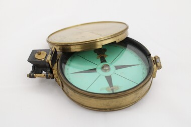 National Communication Museum
Equipment - Prismatic compass, Alfred E Sawtell, before 1872
After years of precursory surveying, debate and proposals the most ambitious civil engineering project of the day, the Overland Telegraph Line, began construction in September 1870. Superintendent of Telegraphs, Sir Charles Todd led the construction through “terra incognita,” guided by the precursory surveys of John McDowall Stuart and technologies such as his prismatic surveying compass. The unknown and hostile landscape claimed the lives of several men and scores of transport animals in the dogged pursuit of telegraphic connection to the rest of the world. Completed in August 1872, the Line connected Australia to the world via telegraph wires running 3,200 kilometres from Port Augusta in South Australia, to Darwin, then connecting via submarine cable to Java and beyond. The “earth [had been] girdled with a magic chain” according to the then Governor of New South Wales, Sir Hercules Robinson. How does it work? For use in surveying, the sight vane and prism are turned up on their hinge and the instrument is held horizontally either in the palm of one's hand or on a tripod. Two small discs of red and green glass attached to the prism can be flipped down over the sight line to reduce glare. The objective is to bring the subject into the sightline created by the prism, aligning with the thread of the sight-vane until the subject is bisected evenly. Once aligned, the division on the card may be read through the prism. This reading provides the magnetic azimuth, used for calculating the bearings of distant landmarks. Circular instrument mounted in a brass case with glass window and brass lid. The compass card face four black compass points printed on mint green paper; on the underside the magnetic needle would be affixed, all held in place by a brass knob at the centre. The arched labels of "Sawtell" and "Adelaide" and the Prince of Wales feathers appear to have been affixed with adhesive which has since yellowed in the areas of application on the compass card. The compass face is printed with numbers, every 10 degrees from 10 - 360, printed in reverse indicating this compass would have once held a mirror at the sighting bracket. On one side of the brass case is a brass hinged sighting-prism, possibly of ebonite. The sighting-prism is mounted in a hinged brass bracket on one edge of the brass case. It has two flip-type filter glasses (red and green) and folds down into a retracted travelling position. A hinged brass bracket on the opposite edge would have held the sighting bracket - carrying the sighting vane and mirror - which is now missing or removed. Under the hinge is a lever, possibly related to the movement of the bracket. Underneath the brass case is an indented circle with screw threads, possibly for attachment to a tripod, and indistinguishable marks scratched into the surface.Etched on to the centre of the lid, "Sawtell ADELAIDE / No 792." Affixed to the paper compass face, possibly from separate pieces of paper, "SAWTELL / ADELAIDE" with the Prince of Wales Feathers above "SAWTELL". Underneath on remains of white tape in red: "159."surveying, compass, charles todd, overland telegraph line, telegraph -
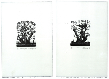 Federation University Art Collection
Print - Artwork - printmaking, 'Messenger' and 'Woe' by David Frazer, 2002
David FRAZER (1966- ) Born Foster, Victoria, Australia David Frazer works in painting, wood engraving, etching, lithography and bronze. He studied a B.A. Fine Arts (Painting) at Phillip Institute of Technology, followed by a Diploma of Education (Secondary- Art/Craft) at Latrobe University in 1991. He completed an Honours Degree in Fine Art (Printmaking (at Monash University in 1996, and between 1998 and 2000 Frazer undertook a Master of Arts (Visual Arts) by research: “Pastoral Melancholia”, at Monash University. One of Austalia's foremost printmakers David Frazer's highly detailed woodblock and linocut prints often explore the emotional and fragile state of the human condition. His work offers a nostalgic image of Australia through its examinations of landscape, Australian buildings, sheds, and itinerant travellers. He has held seven solo exhibitions between 1996-2006 in Melbourne, Sydney and a survey show curated by the Horsham Gallery, which toured Victorian regional galleries from 2004-2005. David Frazer’s work was seen in 37 group exhibitions between 1996-2006 including the 5th British International Miniature Print Exhibition in the UK, in the 2003. He more recently held a solo exhibition with Rebecca Hossack in London 2011. (http://www.thestockrooms.com/, accessed 06/03/2015) David was awarded the Keith Wingrove Bookplate Design and in 2002. These two wood engravings are the subject of the forthcoming Private Press book: ‘The Bookplates of David Frazer’ written by Robert C. Littlewood, The Lytlewode Press, Chateau Bosgouet, Normandie, France, 2014/2015. Two limited edition prints by David Frazer using the wood engraving technique. They have been framed together. .1) Messenger Wood Engraving Plate 10.0cm x 7.5cm Paper 29.0cm x 19.3cm Edition: 32/40 .2) Woe Wood Engraving Plate 10.0cm x 7.5cm Paper 29.0cm x 19.3cm Edition: 32/40 Donated through the Australian Government Cultural Gifts Programme by Katherine N. Littlewood, 2014artist, artwork, frazer, david frazer, wood engraving, framed bookplate, printmaking, bookplates, churchill, gippsland campus -
![Ceramic, Bryan Trueman, [Platter] by Bryan Trueman, 08/1982](https://victoriancollections.net.au/media/collectors/530576742162ef0fa09a2288/items/5566ba552162f113608faa40/item-media/60fbe776101cf8a53354c45d/item-fit-380x285.jpg) Federation University Art Collection
Federation University Art CollectionCeramic, Bryan Trueman, [Platter] by Bryan Trueman, 08/1982
Bryan TRUEMAN (13 November 1941- ) Born Derbyshire, England worked in Australia 1975–1992 Bryan Trueman studied at Blackpool School of Art in 1962, undertaking Postgraduate studies at Manchester College of Art in 1963. He toured the east coast of America in 1967-8, then returned to England where he started to train himself in Ceramics. Migrating to Australia in 1975 Bryan Trueman lectured at Caulfield Institute of Technology, Melbourne. In 1982 he opened a studio in Warrandyte, Victoria. Bryan Trueman was a visiting lecturer to the Gippsland Institute of Advanced Education c1982. He is particularly well-known for his painterly use of glazes to depict the Australian landscape, using the platter as the base form. Bryan Trueman was a visiting lecturer to the Gippsland Centre for Art and Design in 1982. This work is part of the Jan Feder Memorial Ceramics Collection. Jan Feder was an alumna of the Gippsland Campus who studied ceramics on the campus. She passed away in the mid 1980s. Her student peers raised funds to buy ceramic works in her memory. They bought works from visiting lecturers who became leading ceramic artists around the world, as well as from many of the staff who taught there. Wheel thrown stoneware platter, with colourful landscape glaze.Bryan Trueman Aug '82ceramics, bryan trueman, gippsland campus, artists, artwork, jan feder memorial ceramics collection, landscape -
![Print - Artwork, David Frazer, The Text Message [study] by David Frazer, 2015](https://victoriancollections.net.au/media/collectors/530576742162ef0fa09a2288/items/5695ba972162f1130461887c/item-media/5aba2d9e21ea6d0bbcba1e3a/item-fit-380x285.jpg) Federation University Art Collection
Federation University Art CollectionPrint - Artwork, David Frazer, The Text Message [study] by David Frazer, 2015
David FRAZER (1966- ) Born Foster, Victoria, Australia David Frazer works in painting, wood engraving, etching, lithography and bronze. He studied a B.A. Fine Arts (Painting) at Phillip Institute of Technology, followed by a Diploma of Education (Secondary- Art/Craft) at Latrobe University in 1991. He completed an Honours Degree in Fine Art (Printmaking (at Monash University in 1996, and between 1998 and 2000 Frazer undertook a Master of Arts (Visual Arts) by research: “Pastoral Melancholia”, at Monash University. One of Austalia's foremost printmakers David Frazer's highly detailed woodblock and linocut prints often explore the emotional and fragile state of the human condition. His work offers a nostalgic image of Australia through its examinations of landscape, Australian buildings, sheds, and itinerant travellers. He has held seven solo exhibitions between 1996-2006 in Melbourne, Sydney and a survey show curated by the Horsham Gallery, which toured Victorian regional galleries from 2004-2005. David Frazer’s work was seen in 37 group exhibitions between 1996-2006 including the 5th British International Miniature Print Exhibition in the UK, in the 2003. He more recently held a solo exhibition with Rebecca Hossack in London 2011. (http://www.thestockrooms.com/, accessed 06/03/2015) David was awarded the Keith Wingrove Bookplate Design and in 2002.Framed limited edition linocut on paper.lls '2/36' lc 'The Text Message (study)' lrs 'D. Frazer 15'artist, artwork, david frazer, parallel prints, printmaking, linocut -
 Uniting Church Archives - Synod of Victoria
Photograph, St Philip's College Alice Springs - Principal Chris Tudor & Deputy Principal Chris Eldridge, 09/1986
In 1945 the Reverend Harry Griffiths, who worked for the Methodist Inland Mission in Alice Springs, saw the need for a boarding facility for children of families living in remote areas in Central Australia who needed access to schools. He and his wife established Griffiths House, on a site in the town centre, and for many years it became home for students from all over the Outback, including many young Aboriginal people. In the late 1950's the Rev Fred McKay, successor to the Rev John Flynn as Superintendent of the Australian Inland Mission, lobbied the United Church in the Northern Territory to build and expand on this important start. Together the Presbyterian, Methodist and Congregational churches embarked on a missionary venture to develop St Philip's College - a new, larger residential hostel which would one day become a full boarding school. An ideal site - 22 acres of bush at the junction of the Charles and Todd Rivers and backing on to the Telegraph Station National Park - was secured and after six years of planning, construction began in 1964. Fred McKay led the legendary work parties comprised of volunteers from all over Australia who travelled to Alice Springs, paying their own way and volunteering their expertise, time and labour, to turn a dream into a reality. This fantastic tradition continues today, with work parties arriving each mid-year holiday. On 13 February 1965 the first boarders moved in to St Philip's College. For the first 24 years, therefore, St Philip's College operated as a residential hostel only. The College’s ninth Headmaster, Mr Christopher Tudor, arrived in 1986. He and the Council Chairman, Mrs Jan Heaslip, judged that the time was right to complete the original plan to turn St Philip’s College into a fully fledged independent boarding/day school, serving not only “bush” families, but also the growing population of Alice Springs. The then College Council embraced the idea and three years of frantic, determined preparation and planning commenced, culminating in an extensive $2 million building program in 1988. To this day there continues to be further development with the new landscaping underway near The Minnamurra Hall, Reception and Rivergum Cafe, plus the recent completion of the Science & Food Technology building and the new Rivergum Cafe.Head & Shoulders of Chris Eldridgest. philip's college, tudor, chris, eldridge, chris -
 Uniting Church Archives - Synod of Victoria
Photograph, St Philip's College Alice Springs - Principal Chris Tudor & Deputy Principal Chris Eldridge, 09/1986
In 1945 the Reverend Harry Griffiths, who worked for the Methodist Inland Mission in Alice Springs, saw the need for a boarding facility for children of families living in remote areas in Central Australia who needed access to schools. He and his wife established Griffiths House, on a site in the town centre, and for many years it became home for students from all over the Outback, including many young Aboriginal people. In the late 1950's the Rev Fred McKay, successor to the Rev John Flynn as Superintendent of the Australian Inland Mission, lobbied the United Church in the Northern Territory to build and expand on this important start. Together the Presbyterian, Methodist and Congregational churches embarked on a missionary venture to develop St Philip's College - a new, larger residential hostel which would one day become a full boarding school. An ideal site - 22 acres of bush at the junction of the Charles and Todd Rivers and backing on to the Telegraph Station National Park - was secured and after six years of planning, construction began in 1964. Fred McKay led the legendary work parties comprised of volunteers from all over Australia who travelled to Alice Springs, paying their own way and volunteering their expertise, time and labour, to turn a dream into a reality. This fantastic tradition continues today, with work parties arriving each mid-year holiday. On 13 February 1965 the first boarders moved in to St Philip's College. For the first 24 years, therefore, St Philip's College operated as a residential hostel only. The College’s ninth Headmaster, Mr Christopher Tudor, arrived in 1986. He and the Council Chairman, Mrs Jan Heaslip, judged that the time was right to complete the original plan to turn St Philip’s College into a fully fledged independent boarding/day school, serving not only “bush” families, but also the growing population of Alice Springs. The then College Council embraced the idea and three years of frantic, determined preparation and planning commenced, culminating in an extensive $2 million building program in 1988. To this day there continues to be further development with the new landscaping underway near The Minnamurra Hall, Reception and Rivergum Cafe, plus the recent completion of the Science & Food Technology building and the new Rivergum Cafe.Head & Shoulders of Chris Tudor.st. philip's college, tudor, chris, eldridge, chris -
 Uniting Church Archives - Synod of Victoria
Photograph, St Philip's College Alice Springs - Principal Chris Tudor & Deputy Principal Chris Eldridge, 09/1986
In 1945 the Reverend Harry Griffiths, who worked for the Methodist Inland Mission in Alice Springs, saw the need for a boarding facility for children of families living in remote areas in Central Australia who needed access to schools. He and his wife established Griffiths House, on a site in the town centre, and for many years it became home for students from all over the Outback, including many young Aboriginal people. In the late 1950's the Rev Fred McKay, successor to the Rev John Flynn as Superintendent of the Australian Inland Mission, lobbied the United Church in the Northern Territory to build and expand on this important start. Together the Presbyterian, Methodist and Congregational churches embarked on a missionary venture to develop St Philip's College - a new, larger residential hostel which would one day become a full boarding school. An ideal site - 22 acres of bush at the junction of the Charles and Todd Rivers and backing on to the Telegraph Station National Park - was secured and after six years of planning, construction began in 1964. Fred McKay led the legendary work parties comprised of volunteers from all over Australia who travelled to Alice Springs, paying their own way and volunteering their expertise, time and labour, to turn a dream into a reality. This fantastic tradition continues today, with work parties arriving each mid-year holiday. On 13 February 1965 the first boarders moved in to St Philip's College. For the first 24 years, therefore, St Philip's College operated as a residential hostel only. The College’s ninth Headmaster, Mr Christopher Tudor, arrived in 1986. He and the Council Chairman, Mrs Jan Heaslip, judged that the time was right to complete the original plan to turn St Philip’s College into a fully fledged independent boarding/day school, serving not only “bush” families, but also the growing population of Alice Springs. The then College Council embraced the idea and three years of frantic, determined preparation and planning commenced, culminating in an extensive $2 million building program in 1988. To this day there continues to be further development with the new landscaping underway near The Minnamurra Hall, Reception and Rivergum Cafe, plus the recent completion of the Science & Food Technology building and the new Rivergum Cafe.Tudor and Eldridge in conversation with the College in the background.st. philip's college, tudor, chris, eldridge, chris -
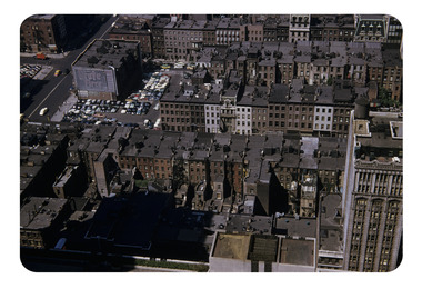 Robin Boyd Foundation
Slide, Robin Boyd, 1956-1957
Robin Boyd developed a close friendship with the founder of the Bauhaus in Weimar Germany, Walter Gropius, who had moved to the USA in the 1930s. Through this connection, Boyd was invited to be the Massachusetts Institute of Technology (MIT) Bemis Professor at the School in the North American academic year 1956-7. Robin and Patricia Boyd, with their youngest daughter Suzy, were based in Cambridge, Massachusetts for the year. Boyd gave some lectures at MIT and he was also invited to give lectures at many other universities, allowing him to travel widely within the USA, especially on the East Coast. This gave him the opportunity to meet architects like Frank Lloyd Wright, Eero Saarinen, Paul Rudolph and many others, and visit the offices of Skidmore, Owings and Merrill, and places like Taliesin and the General Motors Technical Center Detroit. On the way home, the Boyds visited London, Berlin, Paris and Le Corbusier’s Ronchamp Chapel in France.Colour slide in a mount. Manhattan landscape looking down from the RCA building, New York City, New York, USAMade in USA/ RCA Down (Handwritten)/ Encircled 96F (Handwritten)/ 5 (Handwritten)mit bemis professorship, mit, robin boyd, slide -
Federation University Art Collection
Artwork - Bookplates, Suit of wood engraved bookplates by David Frazer
David FRAZER (1966- ) Born Foster, Victoria, Australia David Frazer works in painting, wood engraving, etching, lithography and bronze. He studied a B.A. Fine Arts (Painting) at Phillip Institute of Technology, followed by a Diploma of Education (Secondary- Art/Craft) at Latrobe University in 1991. He compled an Honours Degree in Fine Art (Printmaking( at Monash University in 1996, and between 1998 and 2000 Frazer undertook a Master of Arts (Visual Arts) by research: “Pastoral Melancholia”, at Monash University. David Frazer’s work offers a nostalgic image of Australia through its examinations of landscape, Australian buildings, sheds, and itinerant travellers. He held seven solo exhibitions between 1996-2006 in Melbourne, Sydney and a survey show curated by the Horsham Gallery, which toured Victorian regional galleries from 2004-2005. David Frazer’s work was seen in 37 group exhibitions between 1996-2006 including the 5th British International Miniature Print Exhibition in the UK, in the 2003. He more recently held a solo exhibition with Rebecca Hossack in London 2011. (http://www.thestockrooms.com/, accessed 06/03/2015) These two wood engravings are the subject of the forthcoming Private Press book: ‘The Bookplates of David Frazer’ written by Robert C. Littlewood, The Lytlewode Press, Chateau Bosgouet, Normandie, France, 2014/2015. david frazer, bookplate, wood engraving, printmaking -
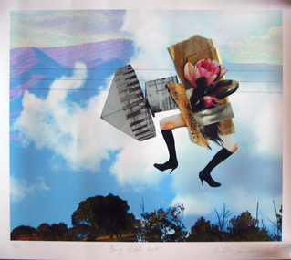 Federation University Art Collection
Work on paper - Photocollage, 'Being Ultra Light' by Rochelle Summerfield
Rochelle SUMMERFEILD Born Sydney, Australia This item is part of the Federation University Art Collection. The Art Collection features over 2000 works and was listed as a 'Ballarat Treasure' in 2007.Artists Statement: I am based in Northern NSW. My art practice is deeply influenced by my connections and experiences with the rivers and habitat where I live. Through drawing, paint, collage and digital media my work explores human relationships with riparian environments. Every day I see the undeniable beauty of our rivers as well as the ecological suffering of these riparian landscapes. Historical practices of land clearing, water politics and weed infestation put tremendous pressure on the Australian ecology. Disrupting traditional art forms, I combine them with new technologies to reveal some of the complexities behind human relationships with nature. With bold collagist experimentation, I combine numerous mediums to expose the small revelations between media. These juxtapositions open up the possibilities of reinventing different ways of being with the natural environment. Like the layers in my work, the issues surrounding our riverine environments are multifaceted and complex and begin with individual choices. I want to direct people’s attention to our rivers, to love, appreciate and reconnect with the natural environment. Human experience with nature is a fundamental part of our sense of self, health and well-being as well as community connection. (https://rochellesummerfield.com/about/, accessed 10 June 2020)art, artwork, rochell summerfield, printmaking, print council of australia -
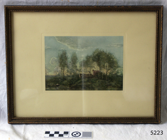 Flagstaff Hill Maritime Museum and Village
Print - Landscape, Jean Baptiste Camille Corot, Souvenir of a Journey to Coubron, 1908-mid-20th century
Famous French artist Jean Baptiste Camille Corot, 1796-1875, was trained in the classical landscape style. His inspiration came from his travels around France and Italy. He developed a soft poetic or romantic style of work which became very popular. He had the skills to bring'light' into his paintings. The original oil on canvas painting by Corot is held at The National Gallery in the United Kingdom. It is titled 'Souvenir of a Journey to Coubron' and is one of twenty-seven of his works at the Gallery. Corot visited Coubon, east of Paris, many times. In 1873 during his stay there he sketched the scene that became the basis of this painting. This reproduction print was made by The Medici Society Ltd., founded in England 1908. The Society's aim was to make artwork affordable and available to the general public. The name Medici was chosen to honour the support and encouragement given to artists in the 15th century by Lorenzo de' Medici (1449 - 1492), known as Lorenzo the Magnificent, and his family. His profile is on the company's trademark. The Medici Society still produces Fine Art reproduction prints as well as selling original works. The print was framed by Westminster Art Gallery in Camperdown, London. The handwritten text on the back of the artwork adds some background to the artist: Corot was apprenticed to a Draper but changed to his profession at the age of 22 years. When he went from a poor artist to achieving wealth and fame he generously supported his less fortunate fellow artists. Corot found that the light and shade in a natural scene meant more to a landscape painter that what could be learned by following the principles of the academies. Corot was 51 years old before he sold his first picture. He though that he was the only artist that could really paint 'light'. The National Gallery, Victoria, has an original oil on canvas by Corot "the bent tree", created 1856-1860. It is in a similar style to this print "Souvenir of a Journey to Coubron", which was likely to have been painted around the same time.This high quality reproduction print was produced in the early-to-mid 1900;'s. This advancement in technology allowed everyday people to own and enjoy the fine art that was previously only accessible to the wealthy. The print is significant for its association with the famous 19th century artist Jean Baptiste Camille Corot.Print of a painting by Jean Baptiste Camille Corot, depicting a landscape with two buildings amongst trees and a boatman in the marshy foreground. The print is famed in carved timber with a cream matt, behind glass. there is an inscription on bottom right of print and further stamped and handwritten inscriptions of the reverse paper. The is a genuine Medici Society Fine Art reproduction print and was framed by Westminster Art Gallery.Original artwork painted and signed by artist "COROT" White sticker with"32" Reproduction print by the Medici Society, London Stamp "Westminster Art Gallery / 91 CAMBERWELL RD. / CAMBERWELL E.6." Text on Corot's history Underlined statement "GENUINE MEDICI PRINT "flagstaff hill, flagstaff hill maritime museum and village, warrnambool, maritime museum, maritime village, great ocean road, shipwreck coast, jean-baptiste-camille corot, french artist, jean corot, camille corot, print, souvenir of a journey to coubron, coubron, 19th century artist, medici society, reproduction print, westminster art gallery, fine art -
 Ballarat Heritage Services
Painting - Artwork, Lisa Gervasoni, Yandoit Creek Summer Oblique ,2021
Interpretation of the Gervasoni farms at Yandoit Creek using a fauvist colour palette.Lisa J. GERVASONI Born Melbourne, Victoria Graduating from Royal Melbourne Institute of Technology where she received a Bachelor of Applied Science-Planning, and the University of Melbourne with a Master of Environmental Studies Lisa Gervasoni's artwork reflects her passion for the landscape and built form. Lisa Gervasoni specialises in photography, embroidery and acrylic paintings on canvas. Many of her works have the theme of interpretation of heritage and cultural spaces. Dedicated to recording cultural heritage in situ Lisa Gervasoni has used photography to document urban areas, heritage sites and natural resources of Australia.She has provided over 70,000 images to the National Library of Australia Trove database via the Flickr portal. In 2004 Lisa Gervasoni won the Daylesford Small Art Prize for an embroidered depiction of the Savoia Hotel in Hepburn Springs, and in 2022 she was shortlisted in the Harden Landscape prize. Her art mediums are photography, embroidery and acrylic on canvas. Many of her works have a theme of interpretation of heritage and cultural spaces. abstract, modernPainted stretched canvas depicting an abstract aerial oblique of Yandoit Creek, Victoria.gervasoni farm yandoit creek, lisa gervasoni, yandoit creek, italo-australians -
 Ballarat Heritage Services
Photograph, Lisa Gervasoni, Dean Store, c2010
I have been interested in urban design and landscape since a child. My early fascination with maps corresponded to early mark making inspired by maps, topography, legends and aerial depictions. This developed into the use of a bold colour palette often used by map makers to delineate sections, contours and geology. Over time I experimented with a range of techniques and enjoy pushing expected techniques and materials to their limits. Often referred to as having a natural aesthetic, my works use various media, most often paint, textiles and photography. Lisa J. GERVASONI Born Melbourne, Victoria Graduating from Royal Melbourne Institute of Technology where she received a Bachelor of Applied Science-Planning, and the University of Melbourne with a Master of Environmental Studies Lisa Gervasoni's artwork reflects her passion for the landscape and built form. Lisa Gervasoni specialises in photography, embroidery and acrylic paintings on canvas. Many of her works have a theme of interpretation of heritage and cultural spaces. Dedicated to ensuring Lisa Gervasoni has used photography to document urban areas, heritage sites and natural resources of Australia.She has provided over 70,000 images to the National Library of Australia Trove database via the Flickr portal. In 2004 Lisa Gervasoni won the Daylesford Small Art Prize for an embroidered depiction of the Savoia Hotel, and in 2022 she was shortlisted in the Harden Landscape prize. Her art mediums are photography, embroidery and acrylic on canvas. Many of her works have a theme of interpretation of heritage and cultural spaces. A depiction of the Dean Store in stitchery. lisa gervasoni, dean, dean store, stichery, textiles, embroidery -
 Ballarat Heritage Services
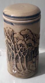
Ceramic, Lidded Container, c1988
Sweenies Creek Pottery was located at 1507 Strathfieldsaye Rd, Axe Creek. Owned and run by Graham Masters, he specialises in a patented technique of low relief stoneware depicting Australian animals and landscapes. Graham Masters graduated from Bendigo Institute of Technology in 197 with a Diploma of Art and Design in Ceramics. He operated a pottery for a year in Bendigo, before working at Maldon Pottery, Maldon, Victoria, with Neville Wilson and Thomas Metcalf. He left Maldon to set up his own pottery at Sweenies Creek in 1984 and has been there ever since. ceramics, sweenies creek pottery, graham masters, australian studio pottery -
 Ballarat Heritage Services
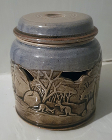
Ceramic, Lidded Container, c1988
Sweenies Creek Pottery was located at 1507 Strathfieldsaye Rd, Axe Creek. Owned and run by Graham Masters, he specialises in a patented technique of low relief stoneware depicting Australian animals and landscapes. Graham Masters graduated from Bendigo Institute of Technology in 197 with a Diploma of Art and Design in Ceramics. He operated a pottery for a year in Bendigo, before working at Maldon Pottery, Maldon, Victoria, with Neville Wilson and Thomas Metcalf. He left Maldon to set up his own pottery at Sweenies Creek in 1984 and has been there ever since. Pierced lidded container by Sweeney Creek Potteryceramics, sweenies creek pottery, australian studio pottery